I picked up backcountry camping and hiking in 2014. The first multi-days backcountry camping was Chilkoot Trail in Alaska, and I think I was hooked completely after this.
This year I decided to give Sunshine Coast Trail a try. It is 180km total in length. It takes about 14 days to complete. I tried to find people who can commit to taking one week to two weeks off was not easy.
I manage to find few people and only one week, so I decided to take on the scenic route of Powell River to Lang Bay segment.
The reason why I choose to do Sunshine Coast Trail?
- It is free camping. (West Coast Trail cost $200 and you need reservation)
- First come first serve.
- Hut to Hut camping. Every 15km there will be a hut that you can stay inside, so camping tent is optional.
- Scenic and it’s ridiculously long distance. I like the challenges.
See the details of Sunshine Coast Trail website at http://sunshinecoast-trail.com/
Prior to the start of the hike, I have to research on few things on the cost, parking and distance.
- Ferry schedules from Vancouver’s Horseshoe Bay to Langdale cost $54 return per standard vehicle plus passenger fee each person $16.15, and then from Earl Cove to Saltery Bay cost $52.60 return per vehicle plus passenger fee each person $15.85.
- The parking situation, we will have two cars. We decided to park one car in Herondell B&B and one car in Townsite residential area street.
- Total KM for this hike is 85km.
- We will pack light tents with us in case we have no space in the hut or we have to stop somewhere that does not have a hut.
After reading at the itinerary from Sunshine Coast Trail website, I get an approx idea how we are going to do our hikes. We still packed our own tents just because we are worried that there will be no space in the huts. Especially summer times.

Day 1. Mowat Bay to Tony’s point (km50.6 to Km55.4, 2 hours)
We left early from Vancouver, approx at 6:40am we got to Horseshoebay Ferry Terminal to get ourselves to Langdale at 7:25am. The ride itself is about 40 to 50min. Once we got off from Langdale terminal, we drive straight to Earl Cove Terminal. The distance between two terminals is about 80km, and about 1.2hr of driving time without stop. We thought we would be able to get on the ferry at 10:25am, but there was such a huge disruption that we didn’t get on the boat until 12:30pm!!! By the time it leaves the terminal it is sometimes after 1pm. So by the time we got to Saltery Bay, it is about 2:30pm.
After getting off from Earl Cove terminal, we head to Powell River, we stopped at the “previously” Herondell B&B (now no longer operational), and talked with the lady Nancy there, she was more than happy to look after one of our cars for few days for $20 until we return. Some people also leave their car at Lang Bay General store, or just near the trailhead too. We couldn’t jeopardize my friend’s nice Lexus Hybrid car so we decide to pay for the parking to have someone to look after the car.
We loaded everything into one car and then we stopped by Powell River’s Tourist Information Centre, by the time we got there, it’s about 4:30pm. The lady working at the centre was super helpful. I was worried about GPS coordinations on the trip, but she said I could download this app on my iPhone called “Avenza PDF maps“, and then just download the SCT segments Map PDF from their website, and this worked like magic!! I couldn’t live without this app from this hike!!

We parked our 2nd car at the edge of Townsite streets, and We started the hike from Mowat Bay around 5pm. Our “original” plan was to get to Inland Lake on Day 1, but we end up parking our tent at “Tony’s point”, it took about 2 hours from Mowat Bay to Tony’s point. The campsite turns out to be a perfect spot for watching the sunset, and taking a dip!


Cell phone reception: Good
Day 2. Tony’s point to Anthony Island Inland Lake Hut (km55.4 to km67, 6 hours)
We started our hike from Tony’s point around 9:30am and heading to Inland Lake, we pass by Haywire Bay (the campsite with amenities, turns out you have to pay for those ones, but Tony’s point campsite is a free campsite!). There’s a little cliff jumping area where you can take a dip and freshen up after the forest trails. We also passed by Lost Lake, which turns out to be a swampy lake surrounding that you don’t have a place to sit. We finally got to Inland lake campsite that we had a little lunch and another 45 min hike in, we reached Anthony Island Inland Lake Hut.

We arrived there at about 3:30pm in the afternoon. We were also the only group who stayed there. It turns out to be a perfect timing to get there, we played a little card game and take some dip in the lake. It says no campfire in the campgrounds, so we just started one on the beach right next to the lake, under the starry nights and campfire, nothing could be more perfect.


Cell phone reception: Good
Day 3. Anthony Island Inland Lake Hut to Fiddlehead Landing Hut (km67 to km82, 8 hrs)
We started our hike from Anthony island Inland Hut around 10:30am towards Confederation Lake hut. The trail itself was dense vegetation, lots of variety of berries on the trail but seems like you need a machete to cut through a path sometimes. We managed to reach Confederation Hut at around 2:15pm, and once we got to the hut, we didn’t like the fact the Hut was dirty, people left behind their trashes there and rat droppings. There aren’t any shades during the day neither and the toilet was an “open” toilet.


So we decided to head towards Fiddlehead Landing Hut. The trail is the same, up and down, and lots of vegetations. We manage to arrive at Fiddlehead Landing at around 6:15pm. This Hut was sooo much nicer than Confederation Hut. It was clean and spacious. There’s an area downstairs where people can sit and cook their meal, and upstairs is a flat open space with door and window where you can sleep inside. There’s a dock on the lake where you can suntan, or just park your tent there as well. I was the only person who stays inside the hut, I had one guy slept in a hammock, two guys slept in a tent right on the dock. The water was also very nice for swimming. It was a very nice campsite after all.


Cell phone reception: No cell phone reception
Day 4. Fiddlehead Landing to Tin Hat Mountain Hut (km82 to Km89, 7 hours)
This would be one of the toughest days we have to go through on SCT. From Fiddlehead landing to Tin Hat Mountain, it is basically straight up. The distance is about 7km, and since we did some extra km yesterday so we could take our time for this hike up. We left Fiddlehead landing around 10:20am, and then working our way up to Tin Hat Mountain. On the trail, we found the bugs were starting to become “annoying”. The mosquitos and black flies are just constantly orbiting and finding the opportunity to bite you. I didn’t put on bug spray nor wear a net just because I find those uncomfortable.
We had to stop at the last water point at around 86.7km area. It took us over an hour to filter the water!! Due to the fact that it was a little stream and we only have one gravity water filter. I had to get my friend to fan off the bugs around me while filter. It was so uncomfortable.

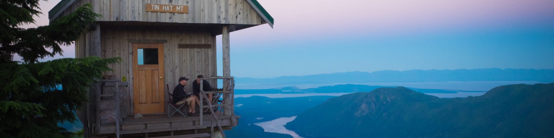
After filtering the water, we finally head up to Tin Hat Mountain, the series of hiking up is definitely not fun when you are carrying a heavy backpack. We reached Tin Hat Hut at around 5:45pm. It was such a rewarding hike when you have 360-degree mountain-top lookout that provides the quintessential view of the rugged mountains, valleys, and lakes that define the Powell River backcountry experience. Instead of sleeping inside the hut, I decided to park my tent right in front of the world class view.


The summit of Tin Hat Mountain is about 200m from the Hut, we head up there for the sunset. It was a breath-taking moment to see the sun goes down and with the mountain range and the sky changing colours. It was absolutely stunning. The only problem was standing there and taking photos were the bugs. The mosquitos and the black flies, they are just horrendous. Last time I encounter this amount of bugs are probably in Yukon. I guess something so perfect always come with a price.


Cell phone reception: Excellent!
Day 5. Tin Hat Mountain to Elk Lake (km89 to km109.3, 11hours)
This is probably another day of tough hiking, not due to the elevation, but more of a distance challenges. We started our hike around 8am, We end up taking the longer route from Tin Hat Mountain through Eat Tin Hat trail, passing Lewis Lake (had a lunch and dip there), and then through the detour, (the shortcut was no longer available), and finally arrive at Elk Lake at around 7pm. I would say the total km that we had walked today is maybe around 23km. Ouch. Glad we made it to Elk Lake. This hut location was slightly colder than other huts, probably because it was in the mountains. The water is still warm enough for swimming. It has a dock going into the water. However the steps connecting the dock and the land area wasn’t so stable, one of my friend manage to trip and fell and lost his cellphone in the lake. If you find a black iPhone 6 somewhere near the dock area, it might be his. 🙁


Cellphone reception: No cellphone reception.
Day 6. Elk Lake to Walt Hill Hut (km109.3 to km123, 6 hrs)
This has to be my 2nd favourite trail in this whole segment. We started the hike from Elk Lake at about 10:20am, We are hiking up in the mountain range, and from time to time, you will get to see a view of the mountain ranges with the lakes. We also passed by Coyote Lake for lunch. Some people might decide to camp there if they don’t wish to do such long trekking. We continued on to Walt Hill.

Walt Hill Hut is actually built on top of the mountain. Our water source at 123km junction was nothing but a small stream of water plus you would have to hike down about 400m to get to the water. It was the only water source so we had no choice but to spend some time to filter there. We finally manage to get to Walt Hill Hut at around 4:45pm. We still have lots of sun to dry our wet clothes, and some ppl decide to pitch their tent around the huts too. Walt Hill Hut is also very new and fully equipped. Not to mention the toilet? World-class compost toilet up on the mountain!
Someone left a bag of potatoes inside the Hut. We manage to find a bottle of canola oil sitting on the shelf, and a camping stove with a full bottle of fuel. The result? Fried potatoes for everyone. It was nice to have something fresh after few days of dehydrated dried foods.

The back of Walt Hill Hut is where you get this spectacular view of Horseshoe Valley with its chain of connected lakes that form the Powell Forest Canoe Route. I stayed up until the evening to see the sunset on this platform someone built for the world-class view.


Cellphone reception: Good
Day 7. Walt Hill Hut to Lang Bay (km123 to 135, 4 hrs)
Today marked the last day of our hike. From here, it is straight down! We wanted to hurry up and get home early, so we left at about 8am, we passed by Suicide Pass and Smokey’s Blue Ridge. Overall the trail is nice and easy and until we get to Stillwater Main and that is where we stopped and head to Herondell B&B to pick up our 2nd car. My two teammates are fast legs that they pick up the car and picked up another car before I reached the end of the trail, and I had a ride right before the trailhead to get to Eagle River. Sweet!
We then finish our hike at around 12pm and head home right after. The first thing we picked up was a nice burger right by the Ferry.
Cell phone reception: Spotty
Review:
Overall, it is a very pleasant trail. Most of the time, we are in the forest, but under the hot sun. It is nice to have shades. Some parts of the trail are heavily vegetated with berry plants. The bonus side of it, you have lots of different berries to eat along the way. There was no bear to be seen, but we have a rope that we carried with us in case we have to camp somewhere that does not have a hut. In the summertime, the bug situation is kinda bad. It is worst up at Tin Hat Hut, I would recommend you to bring a bug head net or bug jacket and antihistamine (allergy pill). You will need it.


Packing List:
1. GOOD hiking backpack, that you know you will need to carry this pack for a good 15km a day. with Raincover.
2. Two people can share one tent unless you love your privacy, then you can carry your own tent.
3. two people can share one set of stove and pots.
4. Bring 3 set of clothes, one for hiking, one for after hiking, and one for sleeping only. Pack fleece and down jacket and a Windstopper shell if you have one. We will stink after 6 days of hiking anyways.
5. Each person please bring your own little first-aid kit.
6. A Headlamp is a must.
7. Hiking boots and an extra pair of socks, and foot balm. (if it rains, you will probably get blister because your shoe is wet)
8. Sandal or flip flop.
9. Swimming wear(I don’t mind you go naked, but really?).
10. Towel.
11. Sleeping bag, Sleeping bag liner (optional), Sleeping pad.
12. Personal Toiletry (toothbrush, paste, face cream..etc)
13. Toilet Paper.
14. Sunscreen.
15. Sunglasses.
16. 6 days worth of food, Freeze dried dehydrate food is probably the lightest you can carry.
17. Hiking poles.
18. Your camera, phones, and battery backups.
19. Water filter (2 ppl share one set).
20. water bottle or bladder.
21. Your eating utensils, bowls, and cups
22. Mosquito Headnet or Mesh jacket (apparently the black fly there is bad!)
23. Gaiter (in case it rains)
24. Your happy self 🙂